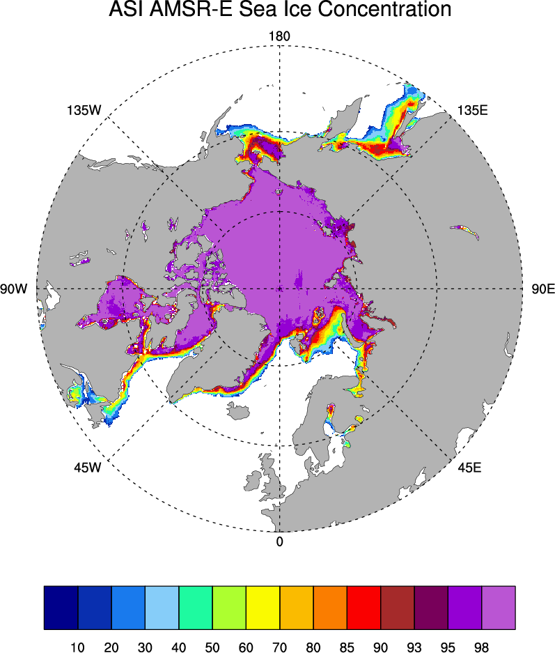
Sea Ice Concentration data from AMSR-E, AMSR2 & SSMIS, U Bremen and U Hamburg ASI algorithm

The sea ice data derived from AMSR-E using the ARTIST sea ice (ASI) algorithm offer a factor of 4 finer spatial resolution than most sea ice data sets from passive microwave satellite instruments. ASI is based on the difference of vertically and horizontally polarized brightness temperatures at 89 GHz; this difference is independent of temperature but depends on emissivity; ice differences are small while water exhibits a large polarization difference. ASI obtains intermediate concentrations by interpolation between these end-member signatures (tie-points). A drawback of ASI is that higher frequencies are sensitive to weather. Nonetheless, the ASI includes adjustments intended to correct for weather using the lower-frequency channels. The AMSR-E satellite died in October, 2011. The AMSR-2 was launched in early 2012, and data are available as of 2013. U Bremen also offers daily sea ice estimates based on the 91 GHz channel of the SSMIS. There are no uncertainty estimates with the data sets, and it is not yet known how merging the AMSR-E, SSMIS and AMSR-2 data impacts apparent climate trends. Version 5.6i is the most recent processing.
Key Strengths
At 6.25 km, finer spatial resolution than many passive microwave sea ice products
May be more useful for flux estimates that the lower-resolution data sets
High-frequency channels (89GHz)-mainly measuring surface emission-make the retrievals potentially less influenced by snow layering than algorithms using lower frequencies
Key Limitations
Short record length for climate studies (AMSR-E satellite died in Oct 2011)
The high-frequency (89 GHz) channel is more sensitive to weather effects (atmospheric water vapor and cloud liquid water) than the low-frequency channels employed by other sea ice products.
The fixed tie points for ice and open water could lead to biases over seasonal and longer timescales due to changing atmospheric and surface conditions and/or degrading satellite instrumentation
Spreen, G., L. Kaleschke, and G.Heygster(2008), Sea ice remote sensing using AMSR-E 89 GHz channels J. Geophys. Res.,vol. 113, C02S03, doi:10.1029/2005JC003384.
the data from Hamburg: Spreen, G., and L. Kaleschke (2008), "AMSR-E ASI 6.25 km Sea Ice Concentration Data, V5.5", Institute of Oceanography, University of Hamburg, Germany, digital media (ftp-projects.zmaw.de/seaice/).
none
Cite this page
Acknowledgement of any material taken from or knowledge gained from this page is appreciated:
National Center for Atmospheric Research Staff (Eds). Last modified "The Climate Data Guide: Sea Ice Concentration data from AMSR-E, AMSR2 & SSMIS, U Bremen and U Hamburg ASI algorithm.” Retrieved from https://climatedataguide.ucar.edu/climate-data/sea-ice-concentration-data-amsr-e-amsr2-ssmis-u-bremen-and-u-hamburg-asi-algorithm on 2025-04-17.
Citation of datasets is separate and should be done according to the data providers' instructions. If known to us, data citation instructions are given in the Data Access section, above.
Acknowledgement of the Climate Data Guide project is also appreciated:
Schneider, D. P., C. Deser, J. Fasullo, and K. E. Trenberth, 2013: Climate Data Guide Spurs Discovery and Understanding. Eos Trans. AGU, 94, 121–122, https://doi.org/10.1002/2013eo130001
Key Figures
Other Information
AMSR-E 89 GHz channel; separate data from SSMIS; planned AMSR-2
6.25 x 6.25 km
- Spreen, G., L. Kaleschke, and G.Heygster(2008), Sea ice remote sensing using AMSR-E 89 GHz channels J. Geophys. Res.,vol. 113, C02S03, doi:10.1029/2005JC003384.
- Spreen, G., L. Kaleschke, and G. Heygster (2005), Operational Sea Ice Remote Sensing with AMSR-E 89 GHz Channels," 2005 IEEE International Geoscience and Remote Sensing Symposium Proceedings, IEEE 6, 4033-4036 (pdf)
- Kaleschke, L. and coauthors (2001), SSM/I remote sensing for mesoscale ocean-atmosphere interactions, Canadian Journal of Remote Sensing, 27(5), 526-537.
- Comiso, J. C., and K. Steffen (2008), Introduction to special section on Large-Scale Characteristics of the Sea Ice Cover from AMSR-E and Other Satellite Sensors, J. Geophys. Res., 113, C02S01, doi:10.1029/2007JC004442.
